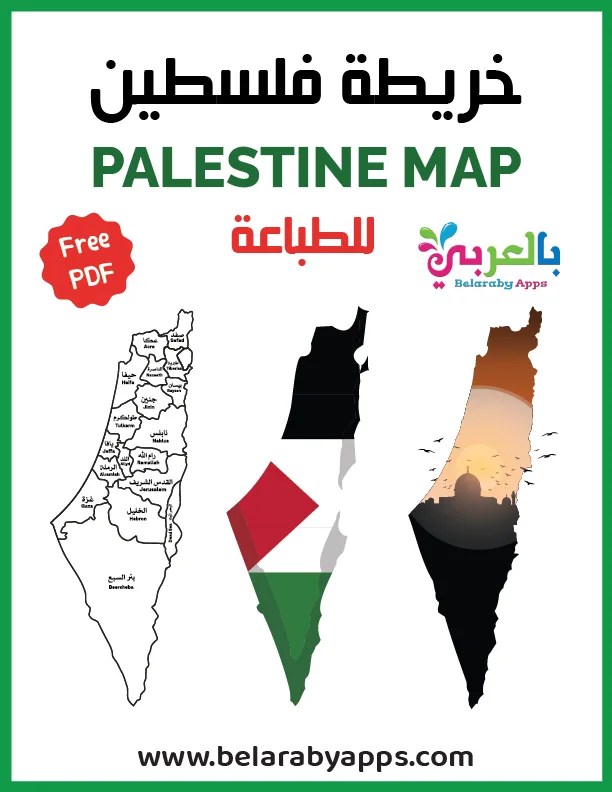
By incorporating the map into your teaching, you can foster a greater understanding of Palestine, its culture, and its place in the world. As educators, we have the power to shape young minds and create global citizens who appreciate the beauty and diversity of our planet. from(BelarabyApps ) Download the Palestine Map Printable PDF today and embark on a journey of discovery with your students
Free!- Palestine Map Printable PDF
Geography is a subject that often captivates young minds with its exploration of different places, cultures, and environments around the world. Palestine, with its rich history and cultural significance, is a region that should not be overlooked in the classroom. To assist educators in teaching geography effectively, we offer a free Palestine Map Printable PDF designed specifically for children. This valuable resource can be a powerful tool for teachers looking to make learning about Palestine engaging and informative.
⇒You may like: Free!- Printable Palestine Flag Colouring Sheet
Outline Map of Palestine
⇒You may like: Free Printable Palestine Flag .. Download PDF
Palestine Map Arabic & English
⇒You may like: 10 Facts about Arabic Language
Palestine Map Flag – free images in English
⇒You may like: Story of Prophet Ibrahim and Ismail for children`s
Palestine map Outline emoji
Enhancing Geography Lessons with Our Free Palestine Map Printable PDF for Children
Download Now !! printable Palestine map PDF
⇒Free Download printable Palestine Map
How to Download the PDF
Downloading the free printable Palestine flag in PDF format is a straightforward process. we offer this resource for free. You can access the PDF by clicking “Free Printable Palestine Flag PDF” on the Button above. Once downloaded, you can print it in various sizes to use in your lessons.
The Importance of Teaching Palestine to Children
Teaching children about Palestine is not only about imparting geographic knowledge but also fostering a deeper understanding of the world’s cultural and historical diversity. Here are some reasons why introducing Palestine into your lessons is essential:
1. Cultural Awareness
By using the Palestine map, children can become more familiar with the various cities and regions within the area. They can learn about culturally significant places like Jerusalem, Bethlehem, and Gaza, gaining insight into the historical and cultural heritage of these locations.
2. Interactive Learning
The map can serve as the foundation for interactive learning activities. For example, you can organize map-based games, such as “Find the City,” to help children locate and identify different cities and landmarks on the map. It encourages active participation and engagement.
3. Geographical Knowledge
The map provides an opportunity to introduce fundamental geographical concepts, such as location, direction, distance, and spatial relationships. Children can explore how territories are divided and understand the importance of coordinates.
4. Connecting Generations
Teaching children about Palestine can also be a way to bridge generational gaps. Students can discuss their lessons with family members, including older generations who may have personal experiences and stories related to the region.
5. Global Awareness
In today’s interconnected world, it’s crucial for children to develop a sense of global awareness and empathy. Learning about Palestine can broaden their horizons and encourage them to think about global issues with a more informed perspective.
Palestine is an area in the eastern Mediterranean region between the Jordan River and the Mediterranean Sea in Asia. Palestine territories include the Gaza Strip, the West Bank, and parts of modern Israel. This region has a strategic location between Jordan in the east, Lebanon and part of modern Israel to the north, the Mediterranean Sea to the west, and Negev and the Gulf of Aqaba to the South. Syria, Egypt, and the Arabian nations are its neighboring countries.
⇒Source: Ministry of Foreign Affairs and Expatriates
Palestine is a geographical region in West Asia. Situated in the Southern Levant, it includes parts of northwestern Jordan. Palestine overlaps with several terms including Canaan, the Promised Land
Situated at a strategic location between Egypt, Syria, and Arabia, and the birthplace of Judaism and Christianity, the region has a long and tumultuous history as a crossroads for religion, culture, commerce, and politics. The region has been controlled by numerous peoples,
Source: Wikipedia
How to Use the Palestine Map Printable PDF
Our free Palestine Map Printable PDF is a versatile resource that can be used in various ways:
- Classroom Decor:
Print the map in poster size and hang it in your classroom. It can serve as a decorative and educational element, providing students with a constant reference point. - Interactive Activities
Organize activities like map quizzes, treasure hunts, or geography bees using the map to test and reinforce students’ knowledge of Palestine. - Research Projects
Assign research projects that require students to explore specific cities or regions on the map. They can then present their findings to the class. - Cultural Exploration
Use the map as a starting point for exploring Palestinian culture, history, and traditions. Integrate discussions about the significance of the landmarks on the map.
Al Israa Wal Miraj (The Night Journey) for Children
the story of Al-Isra’ wal-Mi’raj – that the Prophet (saw) was transported from al-Masjid al-Haram to al-Masjid al-Aqsa, from where he (saw) ascended to heaven. There were many stops along this incredible journey, and the story is packed with wonders and miracles. we have included as much detail as we could. Enjoy!
Hikayat APP .. Best Arabic Stories For Kids
Hikayat App, Read to your child and encourage him to love the Arabic language with more than 500 Arabic stories for children and new purposeful children’s stories in Arabic
Download Now !! .. (Hikayat APP) Arabic bedtime stories for kids


